
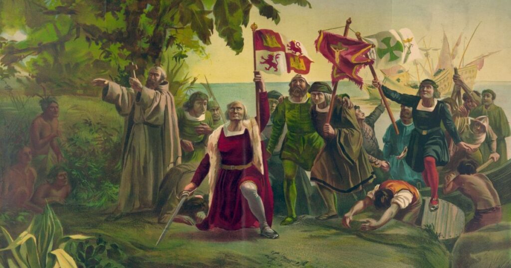
He was only off by six… thousand miles.
Another week, another newsletter. Lucky for you, it’s a banger.
In honor of Columbus Day / Indigenous Peoples’ Day (let’s be honest, we all know who got the short end of that centuries-long stick), we wanted to talk about Columbus’s navigation skills. Or lack thereof. After all, the man died thinking he had discovered a new island of the East Indies—not a new continent. That’s right, Columbus toasted his success in the Bahamas and Florida while sending word back to Spain that he’d reached Asia. Cheers.
As a note, because this is often misconstrued, Columbus wasn’t trying to reach India on his epic voyage, but the spice islands near Japan (more on that later). Why? Because the spices of the East Indies were prime Spanish imports at the time, and Spain wanted to lower its shipping costs.
You heard correctly. Columbus found the Americans because Europeans wanted cheaper nutmeg for their egg nog parties. And, because he’d been searching for the East Indies (not India), Columbus referred to the Native Americans as Indians… The more you know.
No Guts, No Glory
Christopher Columbus managed to sail across the Atlantic Ocean (which at the time was known as the World Ocean, thought to be filled with krakens and leviathans) with little more than the stars to guide him. Let that sink in. No phones, no GPS. Just 4000 miles in a wooden boat using a guestimated map of the world. Each way. Four separate times. Each time thinking that he was still in Asia.
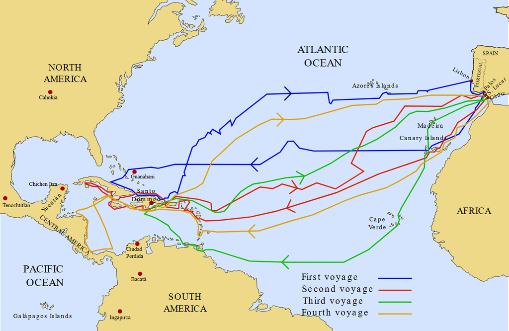
Yup. The guy was a maniac (and that’s avoiding the topic of how he treated the natives).
Brazen though he was, Columbus wasn’t stupid. He didn’t just say, “Send it.” Columbus planned his expedition for six years, having to lobby, negotiate, and curry favor from Spain’s monarchs, so he had to have the data to back up all his claims. Plus, he had been searching for a chain of islands—and accidentally found some. They just happened to be the Bahamas, not the East Indies. A very ironic coincidence—which is why the Bahamas are now referred to as the West Indies.
Fortunately for him, and unfortunately for the Americans, his maps were wrong.
Eyeballing the Mileage (Old Maps)
We don’t pretend to be scholars on the history and techniques of 15th-century cartography (that is, mapmaking), but we are great at trash talking. So, this is how we’d like to imagine things turned out:
Cartographer 1: Where’s Japan?
Cartographer 2: Is that a type of sandwich?
Cartographer 1: No, it’s an island off the edge of China.
Cartographer 2: Oh, that Japan… No idea. I’ve never seen it.
Cartographer 1: Huh. So where do we draw it on our map?
Cartographer 2: See that ocean? Just slap it in there somewhere.
Cartographer 1: Sure. What about the East Indies?
Cartographer 2: Just draw some squiggles around Japan and be done with it.
Now you may be wondering, Why are we picking on Japan? That’s simple. Because Japan was grossly misplaced on the maps that Columbus used to plan his voyage from Spain to the New World. Therein, Japan was placed thousands of miles too far east, which is why Columbus was convinced he could reach Asia by sailing west.
The other major map error? They thought that the Earth was far smaller than it actually is, partly because they had no knowledge of the New World. That one’s forgivable… until you look at the maps that these cartographers made.
Frankly, they weren’t even close.
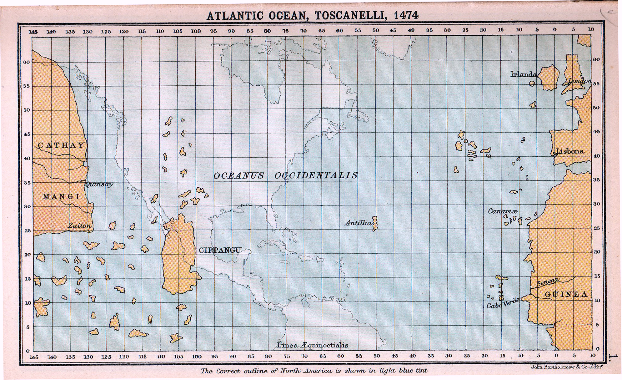
For reference:
- Lisbona = Lisbon (capital of Portugal)
- Guinea = Guinea-Bissau (West African country)
- Cippangu = Japan
- Cathay = Northern China
- Mangi = Southern China
This was a map created by Toscanelli, one of the most respected mapmakers of the time. To Columbus’s credit, he just didn’t know what he was talking about, partly because information was so compartmentalized at the time and measurements weren’t globally standardized. After all, aside from walking and counting “paces” how could people even measure the size of a coastline?
We don’t know either.
Modern Maps
We, thankfully, live in a time where the maps are very accurate, thanks to satellite imaging. So rather than talk about how to make maps, let’s skip straight to the next question: how do we create maps? Specifically, how do we create maps for our fantasy books, like the one in Drowned Sea?
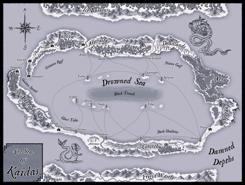
We have two different software packages that we use, depending on the size and substance of the map. For small-scale buildings and districts, we use DungeonDraft. For large-scale continent and world maps, we use WonderDraft. Both are phenomenal tools with cheap one-time fees, avoiding the subscription models that many others have.
As far as how? Well, we just play around with the settings and found out a few things for ourselves:
- Start with the general structure of the world.
- Add in some random islands, ports, and cities to make it look more realistic.
- Use different naming conventions for various regions, while keeping consistent with the world’s theme.
- Add a unique flair to the geography to make it feel different from other fantasy / sci-fi worlds.
- Backfill with historical alliances and wars setting the stage for world conflict.
- Connect the map to the larger narrative of the story you’re telling.
For Drowned Sea, the idea was always for the world to be mostly covered in water, with pirates ruling the seas, so the idea for an atoll continent (that is, a ring-shaped continent) was always our plan. Lots of water, little land.
In the earliest stages of our story, we wanted the main country to be similar to historical seafaring Britain (Aritrasta), and the secondary location to feel more like a religious Rome (Corinthus). In this vein, we wanted Aritrasta to be a naval power (strong navy), whereas Corinthus is a continental power (strong army). So these conventions followed for all their cities, respectively. Similarly, we chose different naming conventions for the lands of Borovia, Tavrak, and Stotan.
From there, we added flair to our story. The godless Drowned Sea, which is filled with roving packs of mutated mermaids (aka syrens). The Deadlands, where nothing grows and the dead don’t die. Even the Black Trench, serving as a sinkhole at the center of the ocean, where ships never return. Around its edge are the colony and pirate islands, outposts created by the Aritrastan Navy before some of the officers went rogue and began their lives as pirates, trading with other countries for the supplies they needed. How better to trade as a pirate than with slaves?
Historically, these pirates have always been kidnapping Aritrastan sailors and merchants, selling them to Corinthus on the southern end of the continent (as shown by the trade routes on the map). This has set up the slave trade and sowed hatred between the two most powerful countries… And set the stakes for Lilyth’s story.
Because the main plot of Drowned Sea is Lilyth’s revenge quest against the pirates who kidnapped her family, we set up our story with personal stakes that send ripples out across the world stage.
You can read more about Lilyth and her adventure here:
Weekly Writing Roundup
Needless to say, here at MW Press, we’re always working on books, whether they are in the outlining, drafting, or editing stage. Below you will find a summary of these in-progress stories:
- Queen of the Labyrinth: Preparing for serialization on Royal Road.
- Uncle Unk Visits the Zoo: Preparing for publication.
- Memories of the Reaper: Edited through Chapter 33.
- Line of Corruption: Edited through Chapter 22.
- Uncle Unk Spends the Night: Illustrated through Page 26.
- Sum of All Forces: Second draft complete.
- Semblance: First draft complete.
- Crimson Ink 2: First short story complete.
- Lady of Beasts: Outline complete.
- Wingman 2: Outline complete.
- Drowned Sea 2: To be rewritten.
Well, that’s it for us here.
Until next time.
Best,
Tristan & Blaise